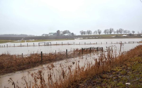
Unusual winter weather walloped local areas as well as Waterloo Region this past weekend, with record levels of rainfall across the Grand River watershed.
Flows in the Grand River running through West Montrose reached the lower threshold of Warning Zone Level 3, said fire chief Dale Martin. Any higher would have resulted in flooded homes.
Portions of the watershed saw an upwards of 100 mm of rain. Martin and Woolwich Township flood coordinators were out until the early morning hours monitoring conditions.
“We had no homes directly [flooded]; we had a lot of water on property,” noted Martin. “It was very, very close … we were watching that. At about 4:30 [Sunday] morning, we noticed that it was starting to recede a bit … then we decided to maybe go and get some sleep. We were very fortunate.”
He added there were several cases of sump pump failures in town throughout the weekend. In addition, the low-level bridge on Three Bridges Road saw nearly four feet of water over the top and remained closed well into the week.
Other local road closures that have since reopened included Glasgow Street and Misty River Drive in Conestogo. Chalmers Forrest Road from Schummer to Ament Line in Wellesley Township was also closed due to the high water levels along the roadway.
Local parks and trails were also affected, such as Bolender Park in Elmira and the trail along Albert Erb Park in Wellesley. Grand River Conservation Authority (GRCA) staff came out to Wellesley village to manually operate the dam to provide more flow, which is atypical for this time of year.
“We did see record-setting rainfall across the entire watershed,” noted GRCA spokesperson Cam Linwood. “This event was the highest January rainfall total in recorded history.”
The majority of that downpour fell between the central portion of the watershed between Cambridge and the New Hamburg area, which received 80-100 mm of rain. The situation became so overwhelming that Wilmot Township residents were using canoes to traverse town.
“This was definitely a very unusual event. We generally don’t see significant rainfall in January,” noted Linwood. “In the case of this event, certainly not of this substantial volume.”
The worst is over now, with the event having moved out of the province earlier in the week. The GRCA issued five separate flood warnings, noting that it was a very unique event to try to predict.
“It was a challenging one to forecast because of the uncertainty of how much would fall as rain, and how much would fall as freezing rain,” said Linwood. “River flows ended up higher than initially forecasted because we did end up getting more rain than freezing rain.”
Many watershed communities saw river flows that were roughly equal to the flooding in June 2017.
There was luckily just a light snowpack across the watershed; if there had been a higher volume of snow, combined with the temperatures and that amount of rainfall, there would have been even greater flooding associated with the snowmelt, said Linwood.
It’s best to remain cautious, however, as a large amount of debris, such as full-sized trees and branches, were washed into the river in the aftermath. The GRCA advised the public to stay away from waterways at this time.
“The important part is reinforcing the safety piece around flows are still up, water temperatures are extremely cold this time of year, and then with that additional factor of debris in the river, it’s certainly not a safe place to be right now,” said Linwood.
“We want to really reinforce that people stay back even though it is quite a spectacle to see.”