Aiming to eliminate detours along the Kissing Bridge Trail, the Region of Waterloo is chipping in $40,000 towards a study on a potential rebuild of the demolished rail bridge across the Grand River just north of West Montrose.
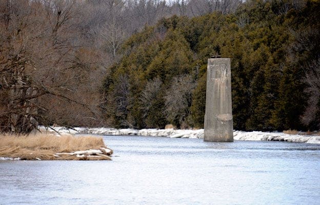
![Abandoned in 1990, the old Canadian Pacific Rail bridge across the Grand River just north of West Montrose could be rebuilt following an engineering feasibility study authorized by the Region of Waterloo. [Scott Barber / The Observer]](https://www.observerxtra.com/content/images/wp-content/uploads/2015/04/news_bridge.jpg)
The provincial tourism body for Huron, Perth, Waterloo and Wellington (Regional Tourism Organization 4) is expected to match the contribution, as part of its bid to promote the development of a contiguous 127 km trail stretching from Guelph to the shores of Lake Huron at Goderich.
But with more than two-dozen trail related projects still in the works along the route, including another major bridge over the Conestogo River near Wallenstein, it’s not going to be an easy road.
“To get the Guelph to Goderich Trail done it is probably going to take, optimistically, $3 million on a four-year, absolute minimum timeline,” explained RTO4 executive Napier Simpson. “Four years would be super ambitious, with everything clicking along and funds becoming available along with permits and a whole bunch of things that aren’t ready yet.”
The Kissing Bridge Trail, also part of the Trans Canada Trail, runs 47 km from Guelph to Millbank along an abandoned Canadian Pacific Rail line. Currently, the path takes a detour at the Grand River, where a CPR bridge was abandoned in 1990, cutting south at Katherine Street before crossing the river by way of the Kissing Bridge at West Montrose.
Reconstruction of old rail bridge would cut out the Kissing Bridge portion from the Guelph to Goderich Trail, although walkers and riders could still choose to take the detour.
“Replacement of the bridge would also be a significant step toward achieving the larger RTO4 goal of having an off-road multi-use trail on the former rail right-of-way from Guelph to Goderich,” Chris Gosselin, a Region of Waterloo environment manager, wrote in a report to council. … “At approximately 130 metres in length, it is well beyond the resources of the trailway steward groups to complete. In addition to its length, its physical setting is challenging. The east bank of the Grand River is significantly higher in elevation than the west bank. Any construction equipment required to install a new bridge would have to use the high steep embankment on the west bank or travel about one kilometre east from the river to descend to the surface of the Trailway and then proceed west to the abutments. When the original bridge was pulled in the early 1990s, the abutments and piers remaining from the original bridge construction in 1904-05 were left behind. Before any new bridge can be designed, it will be necessary to carry out a thorough assessment of the structural integrity of these features. Structural engineers may have to be lowered onto the piers by helicopter. Clearly, this would be a complicated project, and an engineering feasibility study would be required to inform the design and construction of the bridge and prepare cost estimates required for any fundraising efforts.”
With an expected $80,000 budget for the study, there could be money left over for upgrades to the trail’s wayfinding signage, the report added.
But funding for the bridge itself will need to either come from the region’s capital budget, down the line, or from fundraising efforts by trail steward groups, since RTO4 is prohibited from providing monies for capital projects.
The region’s portion of the study costs is coming from its community environmental fund.


